Utsukushigahara
Basic Information
- Spot Name
- Utsukushigahara
- Location
- Wada, Nagawa Town, Chiisagata District, Nagano Prefecture
- Access
- From Matsumoto Station, there is a direct bus to the Utsukushigahara Highlands (typically operating from early June to late September), taking approximately 1 hour and 15 minutes, and it stops right at the Utsukushigahara Nature Conservation Center. Buses run during the summer season.
By taxi from Matsumoto Station on the JR Shinonoi Line, the journey takes about 1 hour.
From Suwa IC on the Chuo Expressway, it takes about 90 minutes.
From Okaya IC on the Nagano Expressway, it takes about 60 minutes.
From Matsumoto IC on the Nagano Expressway, it takes about 70 minutes.
From Tohbu Yunomaru IC on the Joshinetsu Expressway, it takes about 70 minutes.
From Sakaki IC on the Joshinetsu Expressway, it takes about 90 minutes. - Parking
- 【Venus Line Side】
P1 Utsukushigahara Plateau Parking Lot (800 regular cars / 15 buses) (In front of the Utsukushigahara Kogen Station)
P2 Nagawa Town Public Parking Lot (60 regular cars / 5 buses) (In front of Yamamoto Goya Furusato-kan)
【Utsukushigahara Skyline Side (via Misuzuko)】
P3 Utsukushigahara Parking Lot (150 regular cars / 15 buses) (In front of Utsukushigahara Nature Conservation Center) - Business Hours
- Open for visits freely.
- Contact Information
- Phone Number:0263-34-8307
- Official Website
Map
Detailed Information
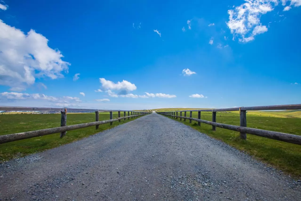
Utsukushigahara Plateau is a vast highland area stretching across Matsumoto City, Ueda City, and Nagawa Town in Nagano Prefecture, at an elevation of about 2,000 meters. Located at the northernmost part of the Yatsugatake-Chushin Kogen Quasi-National Park, it lies near the center of Shinshu. Covering an area of approximately 6 to 7 square kilometers, it is a magnificent plateau often said to be the largest in Japan.
■ Topography and Formation
Utsukushigahara Plateau is known as a gently undulating plateau-like landform (a plateau/tableland) at around 2,000 meters above sea level. It was long thought to be a lava plateau formed by volcanic activity, but another theory holds that it is a peneplain created over a long period of erosion after the uplift of the Sanjō Formation. The summit area is covered with pyroxene andesite, and the rocks are said to carry residual magnetism caused by lightning strikes.
The highest peak on the plateau is Ougatou, at 2,034 meters, and it is counted among Japan’s 100 Famous Mountains. Centered on Ougatou, gentle peaks such as Yakeyama and Takeishimine to the north, Chausu-yama to the south, and Ushibuse-yama to the east connect in a broad arc, while a relatively flat tableland extends to the east. On the other hand, the southwest side of Ougatou forms a cliff, from which visitors can enjoy a grand view overlooking Sanjo Pasture below.
■ A 360-Degree Panorama
The greatest appeal of Utsukushigahara Plateau is its unobstructed 360-degree panorama. It is also called “an alpine observatory,” and on clear days it is said that more than 40 of Japan’s 100 Famous Mountains can be seen.
Major mountains visible from here include:
• The Northern Alps (such as Mt. Yari and the Hotaka Range)
• The Southern Alps Range
• The Central Alps
• Mt. Ontake
• The Yatsugatake Mountains
• Mt. Fuji
• Mt. Asama
• Mt. Togakushi and Mt. Kurohime
• The Chichibu Mountains
The writer Kyūya Fukada wrote in Nihon Hyakumeizan that “Among plateaus, the first I would name is Utsukushigahara,” praising it as an ideal highland that maintains an elevation of about 2,000 meters while offering rich undulations.
■ Symbols and Highlights
● Ougatou
The highest point at 2,034 meters, offering outstanding views. Many radio towers are installed around it, creating a unique landscape where majestic nature and artificial structures blend together. Nearby is Ougatou Hotel, where overnight guests can enjoy special sights such as sea of clouds and star-filled skies.
● Ougadake
A scenic spot located at the western edge of the Utsukushigahara plateau. It offers excellent views of Mt. Ontake and has a history as a base for mountain worship, where many religious groups once gathered.
● Utsukushino-tou
A symbolic landmark standing in the center of the plateau. It serves as a fog bell tower, ringing a bell to help hikers locate their position when thick fog sets in. On the side of the tower are a bronze statue of Shunichi Yamamoto, the developer of Utsukushigahara Plateau, and a poem titled “Utsukushigahara” by poet Kihachi Ozaki.
● Utsukushigahara Open-Air Museum
An outdoor sculpture museum spread across the northeastern slope of the plateau, displaying about 350 contemporary sculptures on a site of approximately 130,000 square meters (about 40,000 tsubo). It is a rare place where visitors can appreciate works of art amid magnificent nature.
The adjacent Michi-no-Eki Utsukushigahara Kogen is known as the highest roadside station in Japan, offering an observatory restaurant and local gourmet dishes.
■ Hiking and Walking Courses
Utsukushigahara Plateau has many well-maintained walking paths, making it safe even for beginners.
• Utsukushigahara Panorama Course: An easy-to-walk path where visitors can casually enjoy spectacular views.
• Alps Viewing Course: A popular course offering views of the Northern and Southern Alps, Mt. Ontake, and Mt. Norikura.
Thanks to its overall gentle terrain, the plateau is ideal for hiking and is accessible even to beginner climbers and families.
■ Pastures and Alpine Plants
The historic Utsukushigahara Pasture lies within the plateau. Its origins are said to date back to a pasture managed by the imperial court in the late Heian period. It was fully developed after the Meiji era, and today about 200 cattle are grazed each year from late May to mid-October on its roughly 600-hectare grounds.
Visitors are not allowed to enter the grazing area or touch the cattle, and drone flights are prohibited.
The flora is also rich, with more than 200 species of alpine plants growing naturally.
Major species include:
• Renge-tsutsuji (most beautiful in late June)
• Japanese scabious
• Nikko daylily
• Fireweed
• Bog bilberry
• Crimson glory lily
• Japanese thistle
In particular, when the renge-tsutsuji blooms in late June, the vivid contrast with the green pasture is especially stunning. From July to August, many alpine flowers bloom in profusion, and in October the plateau is colored by autumn leaves.
■ A Sacred Place for Starry Skies, Sea of Clouds, and Time-Lapse Photography
At an elevation of about 2,000 meters with little artificial light, the night sky is filled with countless stars. The Milky Way and innumerable stars appear with remarkable clarity, offering a dreamlike world completely different from daytime.
The sea of clouds formed by radiational cooling is also famous. The dramatic scenery from before dawn to morning is a special sight that can often be experienced by staying overnight.
Because the weather, clouds, and light change from moment to moment, the area is also popular among photography enthusiasts as a “sacred place for time-lapse photography.”
■ Access
There are two main access routes:
1. Route from the Matsumoto City side
Take National Route 254 and climb from Misuzu Lake. Park at the Utsukushigahara Nature Conservation Center and start your walk from there.
2. Via the Venus Line
Use the scenic Venus Line from the Chino City area. Parking is available at the Utsukushigahara Open-Air Museum, making it ideal for driving and touring by motorcycle.
The Venus Line is a popular route for enjoying spectacular highland scenery, especially in the green season of summer.
■ Notes
Because of the high elevation, weather can change suddenly. Be careful of strong winds, dense fog, and thunderstorms. Even in summer, it is important to bring warm clothing and visit with appropriate equipment based on your physical condition and the length of your stay.
Utsukushigahara Plateau is one of Japan’s premier scenic highlands, spreading across a vast plateau at an elevation of about 2,000 meters. It is packed with diverse attractions, including seasonal alpine flowers, pastoral scenery created by grazing cattle, a 360-degree panorama, star-filled skies, mystical seas of clouds, and even art and cultural facilities.
Utsukushigahara Plateau, where you can enjoy both the grandeur and gentleness of nature, is a special place that reveals a new face no matter how many times you visit.
Utsukushigahara Movies


Nagano Tourist Attractions
View List
Jigokudani Yaenkoen
Jigokudani Monkey Park is located in the northern part of Nagano Prefecture within the Joshinetsu Kogen National Park, at an elevation of 850 meters in a harsh envir...

Matsumoto Castle
Matsumoto Castle is one of Japan's five great castles and is designated as a national treasure, a gem of historical architecture. Alongside Himeji Castle, Hikone Cas...

Ueda Castle
Ueda Castle, located in Ueda City, Nagano Prefecture, is a historic castle built by Sanada Masayuki. It gained fame for repelling the Tokugawa forces during the Firs...


Senjōji Kōdō
Senjojiki Cirque is a bowl-shaped landform formed by glacial erosion, located at Komagatake in the Central Alps. From the "Senjojiki" station at an elevation of 2,61...

Tsumagoshuku
Tsumago-juku is a post town located in Nagano Prefecture along the Nakasendo, and it is the 42nd of the 69 stations connecting Edo and Kyoto. With Ise Mountain to th...


Togakushi Shrine
The highly popular power spot "Togakushi Shrine" consists of five historic shrines: Okusha, Nakasha, Hobokusha, Kuzuryu Shrine, and Hi no Mikokami Shrine. Togakushi ...