Kusasenrigahama
Kusasenrigahama Movies


![[熊本Vlog]熊本阿蘇でドライブの旅|草千里ヶ浜|大観峰|一心行の大桜|新阿蘇大橋|草千里珈琲焙煎所|阿蘇白川駅|長陽駅|KUMAMOTO ASO TRIP](https://i.ytimg.com/vi/RPdg3h8f58k/mqdefault.jpg)


Basic Information
- Spot Name
- Kusasenrigahama
- Location
- 〒869-1404 Kusasenrigahama, Aso City, Kumamoto Prefecture
- Access
- By bus: Take the local bus from JR Aso Station (8.5 round trips per day) for about 30 minutes and get off at "Kusasenri Aso Volcano Museum" stop, which is right in front.
By car: Approximately 80 minutes from Kumamoto City, about 50 minutes from Kumamoto Airport, and around 30 minutes from Minami Aso Village (Michi no Eki Aso No Sato Kugino). - Parking
- Available
- Business Hours
- Free to visit.
- Contact Information
- Phone Number: 0967-34-1600
- Official Website
Map
Detailed Information
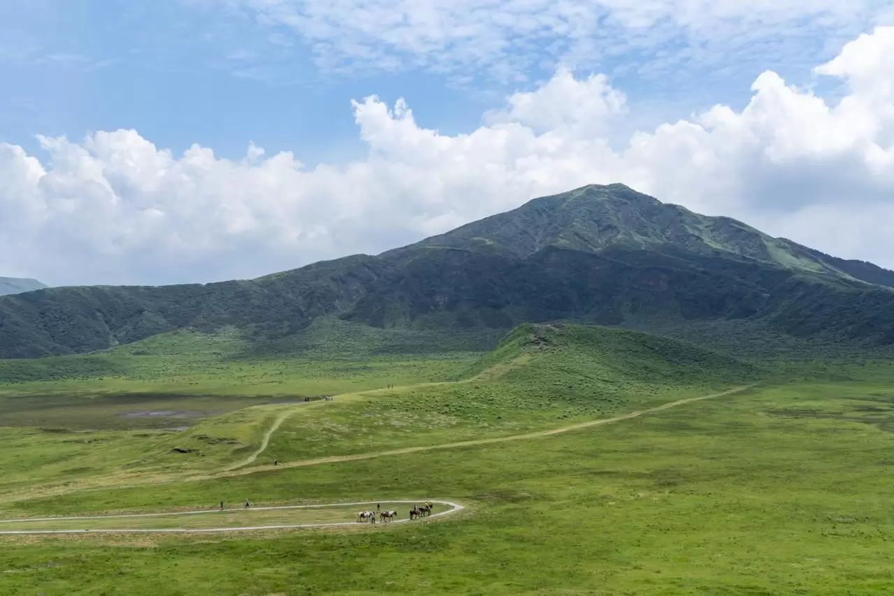
Kusasenri-ga-hama is one of Aso’s most iconic tourist attractions, located in Aso City, Kumamoto Prefecture. At an elevation of approximately 1,100 meters on the northern foothills of Mount Eboshi, one of the Aso Five Peaks, lies a vast grassland measuring about 785,000 square meters and approximately one kilometer in diameter. The landscape features gently rolling hills, two ponds whose appearance changes depending on rainfall, cows and horses grazing during the grazing season, and views of Mount Nakadake to the east, where volcanic activity continues today. This magnificent combination of natural features is widely recognized throughout Japan as a symbol of Aso.
Kusasenri-ga-hama is not simply a highland meadow; it is the remains of a volcanic crater formed by volcanic activity approximately 30,000 years ago. It is the crater of the Kusasenri-ga-hama Volcano, which was active as a parasitic volcano of Mount Eboshi. The site is a double crater, consisting of a large crater approximately one kilometer in diameter with a smaller crater about 400 meters in diameter formed inside it. Although it now appears to be a peaceful grassland, its terrain preserves the history of Aso’s volcanic activity.
Kusasenri-ga-hama is believed to have been formed by volcanic activity that ejected dacitic pumice approximately 30,000 years ago. The inner crater was created when a dacitic lava dome was blown apart by volcanic activity, and part of it remains as a small hill called Komatateyama in the center of the grassland. Komatateyama rises approximately 50 meters above the surrounding grassland and is an important feature for observing the terrain inside the crater.
Two ponds can be seen to the east and west of Komatateyama. The pond on the west lies in the floor of the outer crater, while the pond on the east is located in the inner crater. Because the ponds are formed mainly by rainwater collecting in depressions within the craters, their surface area and water levels vary depending on rainfall and the season. During rainy periods, they hold abundant water, creating beautiful surfaces that reflect the green grassland and the sky. During drier periods, the water level falls, and the ponds may even dry up. The opportunity to encounter different scenery depending on the time of year is one of Kusasenri-ga-hama’s many attractions.
Looking east across the grassland, visitors can see Mount Nakadake. Depending on weather conditions, plumes of volcanic gas rising from the mountain may also be visible. From the same location, it is possible to observe an active volcano alongside cows and horses peacefully grazing in the quiet grassland. This scenery conveys both the powerful force of a volcano and the gentle tranquility of pastoral life. It is a landscape unique to Aso, where volcanoes, local communities, livestock farming, and tourism coexist.
In recognition of its outstanding scenery and academic value as volcanic terrain, Kusasenri-ga-hama was designated, together with Mount Komezuka, as a National Place of Scenic Beauty and Natural Monument under the name “Komezuka and Kusasenri-ga-hama” on March 27, 2013. It was the first Place of Scenic Beauty designated specifically for a volcano. In addition to being terrain that illustrates the history of volcanic activity, it is highly regarded as a scenic location celebrated in works by modern poets and tanka poets.
The grassland at Kusasenri-ga-hama is not maintained solely by natural forces. In the grasslands of Aso, including Kusasenri-ga-hama, grazing, grass cutting, and controlled burning have continued for many years. The controlled burning carried out in spring removes the previous year’s dead grass, suppresses the growth of shrubs and the encroachment of forests, and encourages new grass to sprout. Through these activities, local people have nurtured grasses used as feed for cattle and horses while preserving the area’s open grassland landscape.
The grasslands of Aso are considered secondary grasslands that have been maintained for more than a thousand years through the coexistence of nature and human communities. The scenery of Kusasenri-ga-hama is likewise the result of a combination of terrain created by volcanic activity and traditional pastureland management passed down by local residents. The vast meadow seen by visitors can be regarded as a collaborative work created by nature and people over a long period of time.
One of Kusasenri-ga-hama’s attractions is the way its appearance changes dramatically with the seasons. In spring, new grass sprouts from the blackened ground where controlled burning has taken place, and the grassland gradually changes to a fresh, pale green. Because the site is located at high elevation, spring arrives later than in the lowlands, yet visitors can sense the stirrings of new life even in the cold wind.
From early summer through summer, the grassland is covered in its most vivid green. The contrast among the blue sky, white clouds, green meadow, and the surfaces of the ponds is refreshing, and many tourists visit during this season. Because of its high elevation, the area may feel cooler than urban areas, but there are few places in the broad grassland that provide shade from the sun. When walking in summer, it is important to bring a hat and drinks and take precautions against ultraviolet radiation and heatstroke.
In autumn, the grassland changes from vivid green to golden hues. Pampas grass sways in the wind, and when illuminated by the low-angled sunlight, it creates a calm beauty unlike that of summer. Temperatures can drop quickly in the morning and evening, and the wind may become strong on the mountain, so it is advisable to bring an outer layer that can help regulate body temperature.
In winter, snowfall may cover the entire grassland in a world of silver and white. The hills and ponds blanketed in snow, together with distant Mount Nakadake, create a dreamlike landscape that looks completely different from the green seasons. Depending on weather conditions, the ponds may freeze, and rime ice may also be seen. However, snowfall and icy roads can occur on the mountain, and roads may be closed. Visitors in winter should check weather forecasts and road conditions and prepare winter tires, warm clothing, and other necessary equipment.
At Kusasenri-ga-hama, visitors can walk across the grassland while enjoying its magnificent scenery. Komatateyama, which appears small from the parking area or observation point, gives visitors a tangible sense of the scale of the crater’s interior when approached on foot within the areas open to visitors. However, the grassland is not only a tourist destination but also a pasture where cattle and horses are grazed. The areas accessible to visitors may change depending on grazing conditions and safety management, so it is important to follow local instructions and signs indicating restricted areas.
Horses, especially while grazing, are large animals that may move unexpectedly. Do not approach, touch, or chase them carelessly. It is also prohibited to startle them with loud voices or sudden movements or to feed them. Keep a sufficient distance from the animals, and watch for manure and muddy ground while walking.
One popular activity available in the grassland is horseback riding for tourists. Because the horses are led by staff, this guided riding style is relatively easy for children and beginners to enjoy, provided they meet the participation requirements. From horseback, visitors can view the grassland from a higher perspective than usual. The scenery of Mount Nakadake and Mount Eboshi, seen while gently swaying with the slowly walking horse, offers a charm different from that of exploring on foot.
The tourist horseback-riding season normally runs from early March to late November, but operations may be suspended or changed depending on the weather and the condition of the grassland. Routes, prices, and participation requirements may also change, so those wishing to ride are advised to check the latest information in advance.
The Aso Volcano Museum is located near the parking area. Inside, visitors can learn about the formation, terrain, and geology of Mount Aso, as well as its plants and animals and the relationship between the volcano and local communities, through models, videos, and other exhibits. Visiting the museum before or after walking around Kusasenri-ga-hama helps visitors better understand that the grassland before them is the remains of a crater and gain deeper insight into how Aso’s enormous caldera was formed.
One of the Aso Volcano Museum’s features is its access to footage from a crater camera installed at the Nakadake crater, as well as monitoring cameras located around the crater and on the roof of the museum. Through live and recorded footage, visitors can observe the activity of the volcano. Even when access to the area around the crater is restricted, it may be possible to view conditions at the crater through the camera footage, depending on the circumstances. However, images may not be available because of equipment inspections, communication problems, volcanic activity, or other factors.
The Aso Sanjo Visitor Center is located on the first floor of the Aso Volcano Museum. The center provides information about Aso’s volcanoes, grasslands, plants and animals, hiking, and other topics through panels, videos, and reference materials. Exploring the surrounding area after learning about current volcanic conditions and the natural environment can greatly change the way visitors view the scenery.
Cafés, restaurants, and souvenir shops are also clustered around the parking area. Visitors can enjoy Aso cuisine, including dishes made with Akaushi beef, and purchase specialties from Kumamoto and Aso. Some facilities offer meals and refreshments with views of Kusasenri-ga-hama, allowing visitors to enjoy the magnificent natural surroundings together with local flavors.
The nearby Kusasenri Observation Point is another place well worth visiting. From the observation point, visitors can view Kusasenri-ga-hama and Mount Eboshi to the south, Mount Nakadake to the east, the rice fields of Aso Valley and the Northern Outer Rim Mountains to the north, and the Tateno Volcanic Gorge and the Kumamoto Plain to the west. When weather conditions are favorable, it may even be possible to see Mount Kinbo, the Ariake Sea, and, farther away, Mount Unzen-Fugendake on the Shimabara Peninsula.
Looking west from the observation point, visitors can identify the Tateno Volcanic Gorge, an important feature for understanding the terrain of the Aso Caldera. The gorge is an opening on the western side of the Aso Caldera through which water from inside the caldera flows out toward the Kumamoto Plain as the Shirakawa River. The area around Kusasenri-ga-hama is not only a place to enjoy beautiful scenery but also a valuable geosite where visitors can observe, in three dimensions, the magnificent landforms created by volcanic activity.
Kusasenri-ga-hama is generally reached by car or local bus from the direction of JR Aso Station. On the road leading up to the mountain, the views of Aso Valley and the outer rim change dramatically as the elevation increases. However, access conditions for roads and nearby facilities may change depending on the season, weather, and level of volcanic activity.
In particular, access to the area around the Nakadake crater is restricted depending on the volcanic alert level and the concentration of volcanic gases. Even when the area around the Nakadake crater is closed, Kusasenri-ga-hama may still be accessible. Nevertheless, volcanic activity and road conditions may also affect the Kusasenri area. For this reason, it is important to check separately whether Kusasenri-ga-hama is accessible and whether viewing the Nakadake crater is permitted.
At an elevation of approximately 1,100 meters, the mountaintop area is cooler than the foothills, and weather conditions can change suddenly. Fog may develop even when the sky is clear, and visitors may encounter strong winds or rain. It is advisable to bring a light jacket even in summer and to take adequate measures to stay warm in winter. Because visitors are directly exposed to sunlight and wind across the wide grassland, comfortable walking shoes and clothing appropriate for the season are recommended.
Kusasenri-ga-hama is more than a place to admire green grasslands and grazing cattle and horses. It is a place where a double crater left by volcanic activity approximately 30,000 years ago, two ponds whose appearance changes with rainfall, Mount Nakadake, which remains volcanically active, and a grassland culture preserved through grazing and controlled burning come together.
Visitors can enjoy different aspects of the landscape depending on the season: new growth in spring, vivid green grass in summer, golden pampas grass in autumn, and snow-covered scenery in winter. By walking through the areas of the grassland open to visitors, learning about the formation of Aso at the Aso Volcano Museum, and viewing the caldera’s terrain from the observation point, visitors can gain a deeper appreciation of both the grandeur of Aso’s natural environment and the lives of the people who have coexisted with its volcanoes.
Kumamoto Tourist Attractions
View List
Shirakawa Suigen
Shirakawa Water Source is a representative spring located in Minamiaso, Kumamoto Prefecture, and is selected as one of the "Top 100 Ruins of Famous Water" by the Min...


Aso Shrine
Aso Shrine, located in Aso City, Kumamoto Prefecture, is the head shrine of approximately 500 shrines across Japan and has a history of over 2,500 years. The deities...

Kumamoto Castle
Kumamoto Castle is one of Japan's three famous castles, featuring both the main and small towers side by side. Constructed by Katō Kiyomasa over a period of six to s...

Suizenji Jojuen Garden
Suizenji Jojuen is a nationally designated scenic spot and historic site located in Kumamoto City. It is a stroll garden created by the Hosokawa clan during the Edo ...

Kikuchi Gorge
Kikuchi Gorge is a scenic natural forest located in the northwestern part of the Aso Outer Rim Mountains, and it stretches across a vast canyon at an elevation of 50...

Nabegataki Park
Nabega Falls is a beautiful waterfall with a height of about 10 meters and a width of approximately 20 meters, formed by a volcanic eruption that created the Aso cal...

Green Land
"Greenland," located in Arao City on the border with Fukuoka Prefecture, is one of the largest amusement parks in Kyushu. The park features over 81 attractions, cate...